Environmental Geophysics
Velocity Surveys
As discussed previously, velocity surveys in well bores are a well-established technology in the geophysical industry. An accurate measurement of the travel time and depth location, in combination with a knowledge of travel path, will provide the geophysicist with the necessary velocities to convert the seismic time sections to depth and also to migrate the data properly.
Sonic logs provide these data also; however, sonic logs are usually run only to the surface casing. Tying the information from the sonic log to the surface requires a velocity or check shot survey. Usually, enough levels are obtained in the well bore to provide sufficient detail to forego the data obtained from the sonic log.
Some problems that can affect sonic log data accuracy were discussed briefly in the section on overview of borehole seismic techniques. Seismic travel times are considered accurate within the limitations of sample rate and first break picking accuracy, and sonic times must be adjusted to fit seismic data.
Data Acquisition
Sources for data acquisition must be carefully chosen for the given desired depth penetration. These sources may include explosives, airguns or water guns in containers, or vibrators. Source and acquisition parameters often tend to match those used during acquisition of surface seismic data. Receivers are downhole geophones. A more detailed discussion of source and receiver characteristics will follow in the section on vertical seismic profiling.
In locating the source, an attempt is made to obtain a travel path that minimizes refractive bending through the formations. For the case of horizontal layering and a vertical well, that would imply placing the source close to the well bore. For a deviated well, the source is frequently moved above the receiver in the well. This, of course, requires information from a well deviation survey prior to the check shot survey. Dipping layers can also introduce sizeable changes in travel time because of refraction along bed boundaries.
When working with surface sources such as vibrators, it is advisable to obtain some shallow levels in order to get some information on velocities in the weathered zone. The limitation in this case is the source location, since the drilling platform itself may take up a sizeable space. In addition, refracted arrivals from the top of the subweathering zone or casing may interfere with direct arrival through weathering.
When working with explosives, an uphole high‑velocity geophone is needed to obtain the uphole times. A proper shot depth geophone is needed to obtain the uphole times. Proper shot depth with the uphole time can provide the information on weathering velocities. Shot holes are generally located some distance from the well bore to prevent well bore damage. Therefore, in this case, shallow levels in the borehole may not add much to the survey.
Concerning the placement of geophones in the borehole, the geologists often pick recording depths corresponding to formation tops obtained from logs. If acoustic boundaries of sufficient contrast are in that vicinity, interference between direct and reflected arrivals may lead to errors in first arrival times. Better receiver locations can sometimes be picked below the horizon of interest from existing sonic logs. Another effect may include the gradual polarity reversal of the first break
If receiver spacing is too close, there may be errors in computed interval velocities. In this case, the picking of the first break is rarely more accurate than 1 ms. With a receiver spacing of, for example, 30 m and a velocity of 3,000 m/s, a 1-ms error would amount to a 10% error in the computation of velocities.
Data Processing
When converting travel times to vertical travel times, a straight-line path is normally assumed, as shown in figure 1. Refinement of the results can be obtained by modeling and using the initial straight ray path as a first guess. For a vertical well, the horizontal distance from the source to the well and the vertical distance from the source to the geophone in the well are used. For the deviated well, the horizontal distance from the energy source to the geophone is used in addition to the vertical distance. The azimuth of the energy source is required when corrections for deviations are required. For offset or walk-away shooting, where the source is moved, the coordinates must be known for every shot.
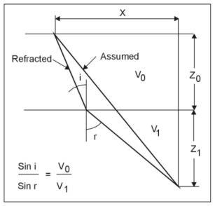
Figure 1. Travel path used for converting total travel time to vertical travel time.
All computations are corrected to the seismic reference datum (SRD). These corrections are summarized in figure 2. Finally, the corrected computations are displayed in the familiar time‑depth plot shown in figure 3. This graph also provides an opportunity for quality control. Points deviating greatly from the trend may require a more detailed evaluation.
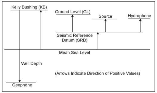
Figure 2. Summary of possible corrections to tie velocity survey to surface seismic data.
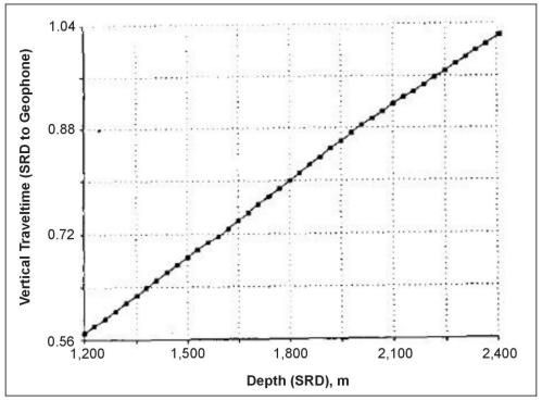
Figure 3. Vertical time depth plot corrected to Seismic Reference Datum (SRD).
Results of the survey or check shot survey are used to tie time to depth and calculate average, interval, and RMS velocities (see figure 4). These velocities are used to study normal moveout (NMO) in data migration and are often used to correct sonic logs prior to the computation of a synthetic seismogram.
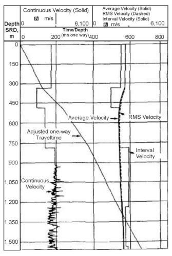
Figure 4. Example of final display from velocity survey with sonic log.
The pages found under Surface Methods and Borehole Methods are substantially based on a report produced by the United States Department of Transportation:
Wightman, W. E., Jalinoos, F., Sirles, P., and Hanna, K. (2003). "Application of Geophysical Methods to Highway Related Problems." Federal Highway Administration, Central Federal Lands Highway Division, Lakewood, CO, Publication No. FHWA-IF-04-021, September 2003. http://www.cflhd.gov/resources/agm/
