![]() A newsletter about soil, sediment, and groundwater characterization and remediation technologies
A newsletter about soil, sediment, and groundwater characterization and remediation technologies
This issue of Technology News and Trends highlights strategies being used to remediate contaminated soil, sediment, or groundwater while restoring a site's ecological system. The strategies involve constructed wetlands, phytotechnologies, and soil amendments.
Multiple Technologies Used to Remediate Groundwater Contaminated with Grain Fumigants
Online Resources
The Phytotechnologies area of EPA's CLU-IN Web site explains the primary mechanisms through which plant-based methods (extraction, degradation, volatilization, sequestration, and hydraulics) can address environmental contaminants. This resource also offers a searchable database currently containing 165 profiles of phytotechnology projects. Learn more at: www.clu-in.org/techfocus/
default.focus/sec/Phytotechnologies/cat/Overview/.
Removal actions at the Murdock Groundwater Contamination Site in northeast Nebraska involve an integrated-systems approach to address groundwater and surface water containing carbon tetrachloride (CT). The contamination resulted from past fumigation practices at a U.S. Department of Agriculture (USDA) grain storage facility in the Village of Murdock. To contain the groundwater plume and promote mechanisms such as rhizodegradation or volatilization of contaminants, the approach combines phytotechnologies, constructed wetlands, and a groundwater extraction and spray treatment system. Investigative and remedial work has been conducted collaboratively by the USDA Chemical Commodities Corporation (CCC), U.S. Environmental Protection Agency (EPA) Region 7, Argonne National Laboratory (ANL), and the Nebraska Department of Environmental Quality (NDEQ).
In 1985, routine testing of the Murdock public water supply by the Nebraska Department of Health (NDOH) identified CT concentrations above the maximum contaminant level (MCL) of 5 micrograms per liter (µg/L). Further NDOH and EPA testing confirmed these findings. In early 1986, EPA conducted an immediate removal action and connected the village to a nearby rural water district. Additional investigations conducted by USDA/CCC and ANL during 1991-1993 indicated a contaminant plume affecting the 20- to 30-foot-thick aquifer underlying the village. The plume migrated from the former grain storage facility in the direction of groundwater flow. Groundwater sampling indicated CT concentrations reaching 6,500 µg/L along the plume's center line. Slightly farther upgradient, a natural spring was found to introduce CT into the headwaters of Pawnee Creek, a tributary of the South Platte River. Follow-up soil sampling revealed CT concentrations as high as 361 micrograms per kilogram (µg/kg), which confirmed that the 5-acre area where the former storage facility stood was the source of contamination. Surrounding agricultural fields showed no evidence of contamination.
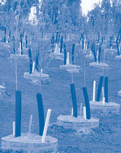
The phytoremediation system focuses on treating shallow groundwater and surface water in the creek's headwaters. In 2005, some 2,000 trees representing six species (green ash, northern catalpa, Niobe willow, black willow, eastern cottonwood, and hybrid poplar) were planted on 4.5 acres to extract contaminated groundwater, effectively intercepting the plume at approximately 5-8 feet below ground surface (bgs) before it reaches the creek. These six species were selected based on their rapid growth, deep rooting, disease tolerance, and non-opportunistic character. Removal of the CT occurs as a result of uptake, transpiration, and volatilization of the contaminated groundwater by the trees, degradation of the CT within the plant tissue, and enhanced microbial activity in the root zone. Groundwater modeling estimated that trees planted along the creek bank would each take up approximately 60 gallons of contaminated groundwater daily during the growing season.
"Tree wells" were installed beyond the immediate creek banks to maximize chances of tree rooting at target depths within the aquifer (Figure 1). To aerate the tree roots and promote growth of naturally occurring contaminant-degrading bacteria, a perforated tube was emplaced as an open loop inside each well.
The phytoremediation system also includes a mixture of native prairie grasses (e.g., big bluestem, Indian grass, switch grass, and western wheat grass) and wild flowers (e.g., baby's breath, black-eyed Susan, coreopsis, and purple coneflower) along with other species planted between the trees and adjacent areas. This cover crop: (1) enhances erosion control; (2) intercepts local precipitation and runoff and, hence, promotes the uptake of deeper contaminated groundwater by the trees; (3) helps protect the trees from physical damage; (4) provides a transitional buffer zone between the tree planting areas and the surrounding croplands; and (5) creates a barrier to herbicide drift.
The shallow wetland constructed immediately downgradient of the main planting area provides an additional remediation polishing step through further degradation by microbial communities and plants. The wetland contains bulrush, arrowhead, sedge, zebra rush, and spikerush covering approximately 800 cubic yards (yd³) over an undulating bottom surface, which adds biodiversity and increases residence time. As designed, the water flows approximately 390 feet through the wetland, which has an average width of 60 feet. This results in a high ratio of length to width (6.5:1). The residence time of water entering from the plantation discharge point ranges from 4.2 to 11.8 days.
The groundwater extraction system is designed to remove contaminated groundwater from the upgradient, more concentrated portion of the plume and provide hydraulic control in hot spots. A single well extending 77 feet bgs is used to extract groundwater at a rate of approximately 29 gallons per minute. The extracted groundwater is piped to a spray-irrigation treatment unit installed at nearby school athletic fields. This custom unit disperses a light spray of the extracted groundwater at a radius of more than 500 feet, a process that simultaneously volatilizes the CT and irrigates the fields. School staff operate the extraction/treatment system seasonally, depending on local irrigation needs and weather. Since 2005 start-up, hundreds of thousands of gallons of contaminated groundwater have passed through the extraction/treatment system.
The spray irrigation treatment unit and the extraction well are operated in accordance with a National Pollutant Discharge Elimination System (NPDES) permit issued by NDEQ. Outfall from the spray irrigation unit is classified by the NDEQ as a land application; as a result, no specific targets for CT removal have been established. NDEQ specifies, however, that the discharge not be toxic to aquatic life in surface waters of the state outside the mixing zones allowed under the Nebraska Surface Water Quality Standards. The standards define a maximum acceptable level of 44.2 µg/L for CT in surface water bodies, which applies to CT levels in surface water discharge from the wetlands to Pawnee Creek.
July-September 2011 groundwater samples indicated an average CT concentration ranging from less than 1.0 µg/L at the point of compliance to 5.1 µg/L immediately upstream of the wetland, a 99% reduction from highest measured concentrations in surface water (7,800 µg/L) prior to remediation. Concentrations of chloroform, a CT breakdown product, have remained at trace levels (below 1 µg/L or not detectable) at the same locations established in the approved monitoring plan.
CT uptake by the planted tree stand has been confirmed by the seasonal presence of CT and chloroform in branch tissue at increasing concentrations and over an expanding areal extent. Significant concentrations of CT in samples from native, deep-rooted grasses where elevated concentrations were found in shallow groundwater and branch tissues indicates that the cover crop may aid the remediation process, as intended.
Trees, native grasses, and wild flowers needed to remediate the site were purchased from local businesses. The USDA engineering evaluation and cost analysis for this project estimates a $538,255 capital cost and $2,985,360 operation and maintenance cost, for a total cost of $3,523,615.
Contributed by Jeff Field, EPA Region 7 (field.jeff@epa.gov or 913-551-7548)
Long-Term Monitoring of Phytoremediation Underway at Aberderdeen Proving Ground
A phytoremediation field study began at J-Field of the Aberdeen Proving Ground (APG) in Edgewood, MD, in the spring of 1996. The purpose was to evaluate the feasibility of phytoremedation as an alternative to pump-and-treat (P&T) technology, which was expected to have limited success due to the site's hydrogeologic conditions. Successful results led to expansion of the study in 2001 by installing approximately 600 additional trees to provide more complete hydraulic containment of the contaminant plume. Monitoring since 2004 indicates that the trees continue to influence onsite groundwater flow and effectively intercept a plume of volatile organic compounds (VOCs). Evaluations also indicate that phytotechnology helps remediate groundwater by biotransforming VOCs within the transpiration stream and by enhancing in situ biodegradation of contaminants in the rhizosphere.
APG is a military installation on the western shore of the Chesapeake Bay. From 1940 through the 1970s, J-Field was used as a test area for chemical warfare agents, munitions, and industrial chemicals. Onsite disposal of test waste, including use of several trenches as burning pits, released chemicals to groundwater and soil. Remedial activities for contaminated soil have involved excavation of hotspots and offsite disposal of soil and sediment with high concentrations of polychlorinated biphenyls (PCBs) and metals, placement of a 2-foot layer of clean soil and geotextile fabric as a protective cover over excavated areas, erosion controls to reduce surface water runoff into the bay, and institutional controls for white phosphorous-contaminated soil. Monitoring has confirmed the presence of dense nonaqueous phase liquid (DNAPL); however, DNAPL recovery efforts are unlikely to be successful due to the tight soil.
The majority of groundwater contamination caused by the burning pits is confined to a low-permeability, 30-foot-thick surficial aquifer at 6 to 7 feet bgs. Groundwater sampling in the surficial aquifer prior to 2001 expansion of the field study indicated high concentrations of tetrachloroethene (PCE) (11 mg/L), trichloroethene (TCE) (93 mg/L), and 1,1,2,2-tetrachloroethane (TeCA) (390 mg/L), as well as 1,2-dichloroethene (DCE) (110 mg/L), 1,1,2-trichloroethane (TCA) (7.1 mg/L), and vinyl chloride (4.2 mg/L). The aquifer discharges to nearby fresh water marshes. Due to the tight soil structure of the silty sand, the rate of groundwater flow is low, at an estimated 10 to 15 feet year. The cleanup objective for J-Field, as part of the APG "Edgewood Area" National Priorities List site, is to use the trees to maintain capture of the plume until MCLs are reached.
The field study involved planting 183 two-year-old hybrid poplar (Populus deltoids x trichocarpa) saplings on approximately one acre along the contaminant plume periphery. The saplings were planted on 10-foot spacings in a single stand. Two years later, approximately 20 tulip trees and silver maples were added to evaluate their performance as native species. A passive drainage system consisting of a series of ditches was constructed to remove surface and near-surface precipitation quickly, thereby encouraging tree roots to access groundwater. Standing water along the drainage system in some areas, however, prompted planting of tree species preferring wetter conditions, such as bald cypress, sycamore, and swamp white oak.
The trees' ability to intercept the plume was evaluated over five years through groundwater modeling and periodic measurement of the water table elevation, tree transpiration rates (based on sap flow and tree growth rates), transpiration vapor data, seasonal hydraulic gradients, natural attenuation parameters in groundwater, and contaminant levels in the plant tissue. A tailored cylindrical dialysis sampler (4 feet in length and 0.16 feet in diameter) was used to measure VOC concentrations in the root zone. Two dialysis samplers also were installed, one directly in the poplar grove (approximately 1 foot from the trunk of a mature hybrid poplar) and the other outside of the grove but in the plume. Upgradient and downgradient groundwater sampling results also were used to evaluate the trees' ability to intercept the contaminant plume.
Peak summer groundwater transpiration rates for the poplar grove were estimated at 2 to 12 gallons per day per tree, based on sap flow measurements. By inducing upward groundwater gradients towards the tree roots during transpiration, the poplars were estimated to shift gradients at depths reaching 25 feet bgs in the summer, effectively limiting discharge of contaminated groundwater from J-Field to the adjacent freshwater marsh. A 2001 groundwater treatability study examined the process by which contaminants are transferred from the tree roots to the leaves and quantified the transpiration rates achieved in the field. Using the transpiration gas and condensate sampling method, for example, TeCA was detected in air ranging from 2.0 to 170 parts per billion by volume. As expected, the highest rate of transpiration occurred during summer growing seasons.
Results of the second five-year review for J-Field in 2008 indicated significant decreases in concentrations of PCE, DCE, and TeCA in groundwater, with increased concentrations of TCE, TCA, and vinyl chloride likely due to breakdown of TeCA. For example, total VOC concentrations in one well had decreased from 15,000 µg/L to 400 µg/L by 2007. Cones of depression and water flow reversals observed during monitoring suggested that the grove provided hydraulic containment of the VOC plume during the growing season except during periods of significant precipitation. During those periods, nearby mature forests (with mixed ages of trees) appeared to have a greater effect on the water table than the seven-year-old phytoremediation grove. This trend suggested that the uptake capacity of individual trees is limited but that the collective capacity of the entire grove would increase with maturity.
Full-scale phytoremediation at J-Field now involves approximately 800 trees (including the original 183 hybrid poplars) covering approximately four acres. In 2010, 32 canker-diseased hybrid poplars were removed and replaced by 130 hybrid poplars of a new canker-free cultivar (Clone OP 367), and 15 additional sycamores, swamp white oak, or bald cypress were installed in drainage areas. Water uptake by the entire grove is estimated at 1,600 to 9,600 gallons per day, depending on the season.
Maintenance activities are conducted monthly to promote health of the grove. The trees are pruned as needed to strengthen plant structure and encourage development of a denser canopy. The grass between the trees is typically mowed four times during each growing season. Habitat of ground-nesting birds is protected during each mowing by 8-foot-wide "birthing strips" between the tree stands and adjacent open fields. Maintenance also includes replacing individual trees affected by weather extremes; for example, approximately 15 poplars were replaced last year following Hurricane Irene.
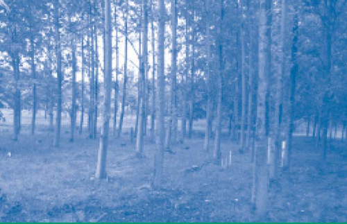
As part of ongoing land stewardship actions at J-Field, APG is currently developing a forest management plan for the phytoremediation grove that will continue to optimize remedial effectiveness of the trees while restoring onsite ecosystems (Figure 2). The plan includes periodic thinning of the grove to avoid stress on individual trees, which increases the grove's susceptibility to disease and decreases water uptake rates. Intermittent replacement of mature trees also will provide the desired mixture of tree ages to maintain a uniform draw on the aquifer. Since annual water uptakes are highest during each tree's growing years, fully mature poplars (12-15 years of age) will be gradually replaced by canker-resistant hybrid poplar saplings. Based on past lessons learned, future plantings will involve bigger spacing among individual plants to avoid overcrowding and nutrient deficiencies and shallower installations to promote more pervasive root systems. During drought conditions, soil amendments or periodic watering will be used to reduce tree stress and assure continued growth. Additional plant species also will be introduced over time to increase plant diversity in the area.
Annual costs for maintaining the phytoremediation grove total $20,000-25,000. In contrast, APG estimates that operation and maintenance (O&M) of a comparable P&T system would cost more than $200,000 each year.
Contributed by Rurik Loder (rurik.a.loder.civ@mail.mil or 410-436-7313) and Scott English (scott.d.english.civ@mail.mil or 410-436-9804), U.S. Army
Long-Term Remediation Combined with Revitalization at Former Chemical Manufacturing Site
Remediation at the former Occidental Chemical Corporation ("Oxy") site in Montague, MI, is closely integrated with revitalization and wildlife habitat creation on this former industrial property. The site restoration plan included amending the sandy soils, expanding wetlands, restoring shorelines, and planting native vegetation that will co-exist with ongoing groundwater remediation work. To date, approximately 65 of 100 acres affected by remedial efforts have been converted to open prairie areas or wetlands. Expansion of the prairie onto the remainder of the site is underway to provide additional habitat and complement long-term forest management activities.
This 880-acre site is located within a region of residential and commercial developments, hardwood forests, dunes, and grasslands in the Lake Michigan basin. A chemical manufacturing facility covering 200 acres operated on the site from 1954 until closing in 1983. Investigations indicated that the facility disposed of approximately 506,000 cubic yards of organic wastes containing hazardous substances in unlined settling ponds on approximately 50 acres. In addition, PCB- and hexachlorobenzene-contaminated sediment was found in adjacent surface water (White Lake) as a result of point-source discharge. Results of groundwater sampling revealed dissolved VOC concentrations exceeding 1 mg/L, which indicated the presence of dense non-aqueous phase liquid. Other contaminants of concern included CT, chloroform, PCE, TCE, and hexachlorobutadiene. The groundwater is at 40 feet bgs within a layer of sand extending 100 feet bgs.
Remedial efforts began in 1981, when approximately 970,000 tons of contaminated soil considered to be one of several source areas was excavated and placed in an onsite, conventional RCRA landfill that included a bottom liner and 10-foot cover of impermeable clay. In 2003, additional soil from hot spots was excavated and disposed of at an offsite facility for hazardous waste, along with approximately 10,500 yd³ of dredged and de-watered sediment containing an estimated 1,100 pounds of persistent, bioaccumulative, and toxic compounds. In addition, a 2-acre former equalization pond was drained, decontaminated through pressure washing and vacuuming, re-lined with a synthetic plastic liner covered by 24 inches of clay, and allowed to refill with rainwater.
To intercept and treat a contaminant plume affecting private wells and the White Lake basin, eight purge wells extending to depths of 100 feet bgs were installed in 1982 along 2,200 feet of shoreline. The extracted groundwater is routed to an onsite treatment plant relying on carbon treatment. Under an NPDES permit, approximately one million gallons of groundwater is discharged each day to White Lake at a point approximately one-half mile downgradient of the plant.
Soil amendments were needed in backfilled areas to physically stabilize the loose soil and address the low organic content left by construction and operation of the former manufacturing facility. Based on results from onsite soil test plots for various plant species, the chosen amendment consisted of a mixture of leaf compost, wood shavings, and manure obtained from a nearby dairy farm. The amendment was mixed onsite and applied on ground surfaces of half-acre parcels through use of a mechanical manure spreader to achieve a 6- to 8-inch layer. A disc cultivator was then used to mix the amendment into the upper soil and destroy remaining weeds.
To stabilize soil and prevent weed establishment during the first year of revegetation, a nursery crop of Canada wild rye (Elymus canadensis) was planted prior to seeding. The areas were then seeded via a standard drill (and broadcast techniques where needed) with several hundred pounds of native prairie grasses and wildflowers. Annual maintenance includes routine harvesting of seeds from the revegetated areas and offsite grassland and, if needed, seed dispersion in areas suffering from drought or unexpected damage.
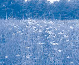
The vegetation is monitored annually for survival, species composition, and invasive plant species. Shipments of manure provide soil amendment for the site on a periodic (commonly weekly) basis. In April 2010, prescribed burning was conducted in the prairie areas to gain the benefits of otherwise naturally occurring fire, which includes control of invasive plant species such as spotted knapweed and provides carbon-rich matter to the soil (Figure 3).
Common cattails (Typha latifolia) native to the area were planted along shores of the remediated pond to establish the new wetland. To expand the prairie areas, native short grasses, tall grasses, wildflowers, and clover (as a winter cover crop) were seeded in adjacent acreage upland of the treatment plant and excavation areas. The combined prairie-wetland now provides a drinking water source for wildlife, haven for migratory waterfowl and wading birds, habitat for aquatic insects, and year-around home to small mammals such as muskrats and mink.
The shoreline enhancement is conducted through the federal Great Lakes Restoration Initiative in partnership with the Muskegon Conservation District. Most of the remaining 800+ acres of this site are covered by forest managed by Occidental Chemical Corporation under the Michigan Department of Natural Resources Forest Stewardship Program. Other partners include the Wildlife Habitat Council, Pheasants Forever, Ruffed Grouse Society, and USDA Natural Resources Conservation Service.
Ecological System Services
Ecosystems provide various services to human populations, such as flood protection, water purification, and climate control. EPA's consensus-based Valuing the Protection of Ecological Systems and Services: A Report of the EPA Science Advisory Board (EPA-SAB-09-012) examines the value placed on these services, including both the economic and non-economic methods of valuation. Access the report at: www.epa.gov/ecology/publications.htm.
To date, costs to operate the groundwater treatment plant total $1.2 million. Cumulative costs for site remediation over the project life, including long-term monitoring, are estimated at $10.8 million. Project partners are investigating other opportunities for reuse of the site as cleanup continues, such as developing a hydroelectric system to capture energy from outfall of the water treatment plant and developing an extension of the community's "rail to trail" recreational network.
Contributed by Kenneth Bardo and Carolyn Bury, EPA Region 5 (bardo.kenneth@epa.gov or 312-886-7566 and bury.carolyn@epa.gov or 312-886-3020)
Technology News and Trends is Going Paperless!
In the interest of minimizing the resources required to print and distribute Technology News and Trends, EPA is going paperless. Starting with our June issue, we will cease mailing printed copies of the newsletter to our subscribers and will limit subscriptions to email notifications of its online availability. If you currently receive ONLY printed copies, please send your email address to TNTeditor@emsus.com. You will receive your future copies of the newsletter via email. Thanks to all of you who have already contacted us! We look forward to an online version that will offer more resources to our subscribers.
