![]() A newsletter about soil, sediment, and groundwater characterization and remediation technologies
A newsletter about soil, sediment, and groundwater characterization and remediation technologies
This issue of Technology News and Trends highlights innovative strategies for integrating ecological restoration into intrusive cleanup remedies or applying ecologically based approaches to passively treat contaminated media.
Wetland Restoration and Creation Completes Remedy Construction Near Buzzards Bay
CLU-IN Resources
The EcoTools web page on CLU-IN now offers technical assistance to remedial project managers with questions about ecological land reuse at Superfund sites. The service focuses on appropriate use of soil amendments, selection of native plants, avoidance of invasive species, and effective strategies for revegetation. Questions may be submitted online at www.clu-in.org/ecotools/sf.cfm.
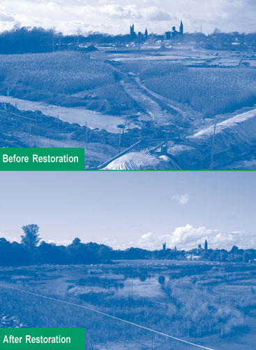
The U.S. EPA's Region 1, U.S. Army Corps of Engineers, National Oceanic and Atmospheric Administration, and Massachusetts Department of Environmental Protection (MassDEP) collaborated last year in implementing the final phase of a three-phase remediation project at the 48-acre Atlas Tack Corporation Superfund Site in Fairhaven, MA. Phases I, II, and III involved demolition, excavation, and offsite disposal of approximately 73,000 yd3 of contaminated soil, sludge, and debris and 35,000 yd3 of contaminated marsh soil and creek-bed sediment between 2005 and early 2007. Phase III work also included wetland restoration and creation that began in June 2007 and ended three months later, at which time the entire site attained a "construction complete" status. Approximately three acres of fresh-water wetland had been created, and eight acres of salt-water marsh were restored.
From 1901 until 1985, the Atlas Tack Corporation used this site for manufacturing small metal products, which involved electroplating, acid-washing, and painting operations. From the 1940s until the late 1970s, wastes were discharged into a 10,000-ft2, unlined, acid-neutralizing lagoon adjacent to a salt-water tidal marsh in Buzzards Bay Estuary—a federally designated estuary of national significance. As a result, surrounding soil, wetlands, and ground water were contaminated with heavy metals, cyanide, volatile organic compounds (VOCs), polycyclic aromatic hydrocarbons (PAHs), pesticides, and polychlorinated biphenyls (PCBs). Cleanup goals for onsite soil were based primarily on the ecological risk posed by constituents such as copper, zinc, lead, antimony, cyanide and 4,4'-DDT. In a 10-acre commercial area, however, human health-based cleanup levels also were used for PAHs, PCBs, lead, and arsenic. Ground-water interim cleanup levels were based on ecological risks for copper, nickel, zinc, cyanide, and toluene.
The lagoon was partially remediated in 1986, but additional efforts were required for contaminant source removal. A 2000 record of decision called for excavating only a portion of the 30-acre marsh that served as a contaminant source. Results of a 2001-2004 bioavailability study, however, indicated that excavation of a larger area was required to meet cleanup goals. For each marsh and onsite creek bed sediment sample, metals concentrations were correlated to toxicity data to establish an effects range median quotient (ERMQ); an ERMQ higher than 1.0 indicated significant toxicity and required remediation, while a value less than 1.0 indicated little to no toxicity. Based on this threshold, a total sediment volume of 35,430 yd3 was excavated instead of the 16,000 yd3 originally estimated. The highest contaminant concentrations in the marsh were closest to the source areas (fill areas and the former lagoon), but hot spots were identified at greater distances. Approximately 1,500 yd3 of sediment also were excavated from a creek onsite.
Design of the wetland called for integrating both fresh-water wetlands and salt-marsh areas, which were challenged by invasive plant species. In the early 1960s, a hurricane barrier had been constructed with an undersized culvert that prevented adequate tidal flow to the northern marsh. As a result, the marsh had decreased in size, and common reeds (Phragmites australis) had invaded the area over time. Following removal of all Phragmites during cleanup activities, a three-acre, fresh-water wetland and a six-acre sustainable salt-water marsh were constructed in the newly remediated area, along with a clay core earthen berm to separate the two wetlands. Reinvasion of Phragmites was prevented by designing the bottom of the fresh-water wetland to be at or below ground-water level and to create a 2:1 slope on all sides.
Site restoration involved installing thousands of native plants and seeding of wildflower mixes. Trees and shrubs installed at upland locations included red maple, oak, sweetgum, blackgum, pepperbush, inkberry, bayberry, and elderberry. Fresh-water herbaceous plantings included green ash, black gum, swamp white oak, black willow, buttonbush, winterberry, marsh elder, sedges, soft rush, bullrush, spatterdock, pickerelweed, wool grass, and duck potato. Salt-water species comprised mainly seashore saltgrass (Distichlis spicata), saltmeadow rush (Juncus gerardi), and salt hay (Spartina patens) for high marsh areas and salt-marsh cordgrass (Spartina alterniflora) for low marsh areas (Figure 1). Two acres on the opposite side of the hurricane barrier also were remediated and restored.
Nine 15-foot-diameter islands planted with deciduous scrub and herbaceous vegetation were created in the fresh-water wetland to maximize habitat area and variability. To further minimize encroachment of invasive species (primarily Phragmites), a sizable area of marsh remediated downstream of the hurricane barrier was lowered 6-12 inches in elevation and vegetated with salt-marsh cordgrass. Any remaining stands were treated with a synthetic, non-selective aquatic herbicide. Plans for using tree-based phytoremediation were terminated after creation of the fresh-water marsh; field studies indicated that tree plantings would significantly reduce ground-water infiltration to the marsh, consequently risking reinvasion of Phragmites.
The total cost of implementing all phases of this project, including one year of operations and maintenance (O&M), was approximately $20.6 million. Annual O&M costs for the first five years are estimated at $50,000. Plantings were monitored and maintained by EPA for one year after which responsibilities were transferred to MassDEP. Ground-water monitoring will be conducted by EPA for 10 years and by MassDEP for another 20 years or until cleanup goals are attained. Due to contaminant source removal, natural attenuation is expected to help achieve ground-water cleanup goals within 10 years. The wetland and marsh will remain undeveloped in accordance with federal and state requirements for wetlands protection.
Contributed by Elaine Stanley, EPA Region 1 (stanley.elainet@epa.gov or 617-918-1332)
Phytoremediation with Innovative Irrigation Technique Treats Arsenic-Contaminated Soil
Superfund removal actions were initiated in early 2005 at the Crozet Orchard near Crozet, VA, to address residential properties exhibiting high concentrations of arsenic in soil. Cleanup activities focused on excavation of contaminated soil followed by construction of an in situ phytoremediation system. Plant growth and consequential uptake of contaminants were accelerated by installing irrigation systems employing onsite spring water. Passive gravity and photovoltaic energy systems were used to power the irrigation pumps during dry spells. The initial plant harvest indicated that phytoremediation had decreased contaminant concentrations in soil of all but one treatment plot. Project results also demonstrated that renewable energy provided sufficient energy for the irrigation system, consequently increasing the rate of soil treatment while avoiding utility expenses and associated greenhouse gas emissions.
Orchards once occupied much of this property, which is situated in the Blue Ridge Mountains. Application of lead-arsenates and other pesticides was common in the 1940s and 1950s. The site currently encompasses numerous properties of varying sizes that are managed as two cleanup areas: "Area 1", which is a residential development comprising more than 100 properties, and "Area 2," a single property covering 27 acres within a residential zone.
Ground-water sampling indicated no contaminant concentrations above background levels. Soil sampling at approximately 50 properties, however, led to short-term removal actions at two residential properties to prevent human exposure to arsenic, lead, and pesticides. Soil in one Area 1 residence contained arsenic concentrations ranging from 50 to 103 ppm, lead at a maximum concentration of 431 ppm, and pesticides at levels above 3.4 ppm. At a second residence of concern in Area 2, arsenic and lead were present at levels reaching 111 ppm and 594 ppm, respectively, but elevated concentrations of pesticides were not found. As a result, arsenic served as the driving risk factor for removal actions within both residential areas.
Based on bioavailability assessment results, the risk-based action level for arsenic was set at 58 ppm; soil with concentrations above this level required remediation. Accordingly, excavation was conducted on 12 Area 1 properties. The top six inches of soil were removed until one of three conditions was attained: background levels were encountered, a two-foot depth was reached, or the clay pan was reached. All excavated soil was disposed offsite at a RCRA-regulated landfill. Excavated areas subsequently were backfilled with onsite soil taken from non-contaminated areas and revegetated with grass. A total of 99 tons of soil was removed from three plots at a cost of approximately $18,000 per plot.
Phytoremediation was implemented in 27 of the 30 Area 2 plots where excavation was infeasible due to difficult access, significant erosion potential posed by hillside terrain, or dense forestation. The Chinese brake fern (Pteris vittata) was selected due to earlier University of Florida studies showing that the plant could hyperaccumulate 200 times more arsenic than other fern varieties. Each plant also could extract 20-50 ppm of arsenic per growing season from a square foot of soil. Subsequent U.S. Army Corps of Engineers tests on a patented variety at the Spring Valley formerly used defense site in Washington, DC, demonstrated the plant's field success.
Approximately 20,000 Chinese brake ferns of the patented variety were installed in the summer of 2005. Soil preparation involved clearing and tilling, light application of fertilizer, and installation of landscape fabric. First-year operations included collection of baseline plant data and installation of moisture and light meters to guide irrigation and predict rates of contaminant uptake. Heavy tree canopies provided optimal growth conditions, as anticipated, but the compacted clay soil typical to the area was found to slightly inhibit plant root development that in turn reduced arsenic uptake.
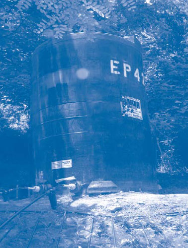
Different irrigation systems were installed to take advantage of two onsite springs with a combined production capacity of 5,000 gallons per day. One system relies on a hilltop spring feeding water into a 4,000-gallon storage tank. When needed, water is transferred by gravity to 17 plots in sloped non-residential areas of the site (Figure 2).
The second system services seven of the plots through use of solar-powered, low-flow pumps that transfer water from a hill-bottom spring to another storage tank from which water is delivered to plots by gravity-fed drip methods. Electricity to power the pumps is generated by an off-grid, 390-watt, solar array composed of three 12-volt photovoltaic (PV) panels. The PV system meets approximately 85% of the energy needed for full-capacity pump operation. Absence of a battery for storage of excess electricity causes overnight shutdown of pumping operations, consequently allowing water replenishment in the storage tank.
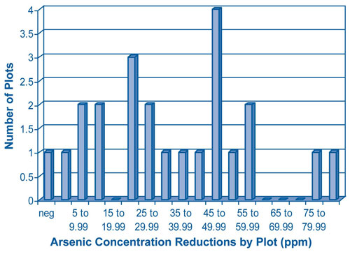
Ferns planted during the first year of the project (2005) were harvested in November 2007, generating 12 yd3 of material that was disposed offsite as hazardous waste. The ferns in several plots bioaccumulated more than 1,000 mg/kg of arsenic and in some cases almost 1,900 mg/mg. Analysis of soil collected from remediated plots indicated reduced arsenic concentrations ranging from 18 to 114 ppm; only one plot exhibited no reduction. Seven of the 27 phytoremediation plots exhibited arsenic concentrations below the action level of 58 ppm within approximately six months of plant growth and required no further action. With arsenic concentrations of 58-68 ppm, five additional plots are nearing the action level (Figure 3).
Phytoremediation will continue until the action level is met at the remaining plots, and re-evaluation of the approach will be conducted three years later. Soil sampling at 55 residential properties in Area 1 shows 11 more properties qualify for removal actions. Follow-on sampling of pesticides in soil in non arsenic-contaminated areas will be conducted to determine the need for additional actions. Removal actions are not anticipated in non-residential areas, including remaining orchards.
Pending the results of current soil tests, project closeout may occur at the end of 2008. EPA’s initial action memorandum required at least three years of plant growth prior to final decision-making. Projects costs total approximately $1 million, including $11,000 for each of the 24 irrigated phytoremediation plots.
Contributed by Myles Bartos, EPA Region 3 (bartos.myles@epa.gov or 215-814-3342)
River Diversion, Excavation, and Ecorestoration Collectively Achieve Site Reuse
Discovery of an oily sheen along a quarter-mile stretch of the Cache la Poudre (Poudre) River in 2002 led to extensive site remediation and revitalization efforts in downtown Fort Collins, CO, which were completed last year. Selection of an innovative remedy was driven by the need for access to the Poudre River (a popular recreational waterway and federally designated wild and historic river) and anticipated site reuse involving a new community center and recreational areas. Cleanup actions included contaminated sediment removal, upgradient plume control, and redirection of the river in order to treat ground water.
Contamination resulted from past activities conducted along the river. The site contains a former 12-acre municipal landfill that operated from the late 1930s to the early 1960s, and an agricultural machine shop is located on an adjacent property. Located a short distance upgradient, a manufactured gas plant (MGP) generated coal tar as a major byproduct from 1900-1930. In later years, portions of the former MGP property were purchased by a gasoline supply company and an energy utility company.
Site investigations indicated ground water was contaminated with PAHs; benzene, toluene, ethylbenzene, and xylenes (BTEX); total petroleum hydrocarbons (TPH); methyl-tert-butyl ether; trichloroethene; and tetrachloroethene. Subsurface soil and river sediments remain impacted by non-aqueous phase liquid (NAPL) containing PAHs, BTEX, and TPH. In-depth investigations in 2003-2004 determined that NAPL stemmed from coal tar likely mixing with gasoline from a leaking underground storage tank. Mixture of the two changed the chemical and physical nature of the gasoline, in turn changing NAPL mobility; contamination moved along the sediment alluvium and ultimately flowed through bedrock fractures to the river. As a result, NAPL existed in sediments along a 300-foot stretch of the Poudre River as well as a 600-foot stretch of bedrock under the river. Coal tar existed at the river bottom.
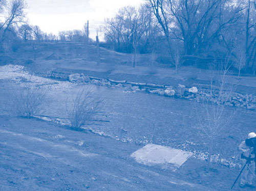
EPA selected a combined remedy involving excavation of contaminated sediments, creation of a vertical sheet pile barrier with hydraulic controls to intercept NAPL before it reached the river, redirection and treatment of ground water, and restoration of the excavated area to restore the natural appearance and recreate wildlife habitat. To excavate contaminated sediments, the Poudre River was dammed and its flow was temporarily rerouted through pipes. The dam was completed in phases to gradually reduce water in the contaminated stretch of river while allowing fish to travel downstream. Screens were placed on pumps as an additional measure to protect fish.
The U.S. Fish and Wildlife Service assisted EPA in evaluating ecological aspects of site cleanup. Concerns were addressed through strategies such as bank undercutting in ways that mimicked natural conditions, thereby providing fish resting areas. To provide habitat, boulders were incorporated into the stream bank, and snags (dead trees) were preserved and replaced on the bank following excavation.
Principles of low impact development (LID) were used to reduce the impact of built areas and promote natural movement of water within the ecosystem and watershed. One LID strategy involved careful selection of sizes and types of stones and other material to be placed in the riverbed, and material placement in manners replicating the river’s original contours and flow pattern (Figure 4).
Invasive plant species such as Russian olives and thistle brush were removed during excavation whenever possible and replaced by native species such as coyote willows and Colorado sedges. One important lesson learned was to establish an acceptable plant survivability rate at the project onset to account for plant die-offs. Approximately half of the original tree plantings were consumed or destroyed by beavers; as a result, painted wire was installed to protect the bottom 6-8 feet of remaining and subsequent tree plantings. Overall plant survival was 80% for trees and 75% for native plants.
Due to contaminant source material left in place, the City operates an extensive monitoring system. Wells for analytical sampling were constructed along the full length and beyond the barrier wall. In addition, tubes with a pulsed removal and hydraulic control system were installed in the sheet pile barrier to address coal tar as it accumulates. EPA will monitor the system's performance indefinitely.
Contributed by Paul Peronard, EPA Region 8 (peronard.paul@epa.gov or 303-312-6808)
New EPA Tools for Ecological Restoration
EPA's Office of Solid Waste and Emergency Response (OSWER) recently compiled a report entitled Ecological Revitalization: Turning Contaminated Properties Into Community Assets to highlight guidance documents for cleanup planning, outline important considerations, and provide site-specific case studies concerning ecological revitalization. The document covers wetlands, stream, terrestrial, and long-term stewardship issues frequently encountered at Superfund, federal facility, RCRA correction action, brownfield, and underground storage tank sites. In January 2009, the full report (EPA 542-R-08-003) will be available on CLU-IN's EcoTools web page (www.clu-in.org/ecotools/sf.cfm).
OSWER also is collaborating with EPA's Environmental Response Team (ERT) to research opportunities for terrestrial carbon sequestration on contaminated lands, as part of the Agency's strategy for addressing climate change. Analytical samples were collected in recent months at sites in Leadville, CO, Stafford, VA, and Sharon Steel, VA, where soil amendments were used in the past for remediation purposes. Project objectives include (1) developing a field and laboratory protocol for sequestration measurement and (2) identifying the amendment application techniques, plant types, and amendment or revegetation locations that maximized carbon sequestration. Study results will be available in 2009; for more information, contact Harry Compton, ERT (compton.harry@epa.gov or 732-321-6751).
