
Green Remediation Focus
Kerr-McGee Navassa Superfund Site
Navassa, North Carolina
Superfund NPL
Image Gallery
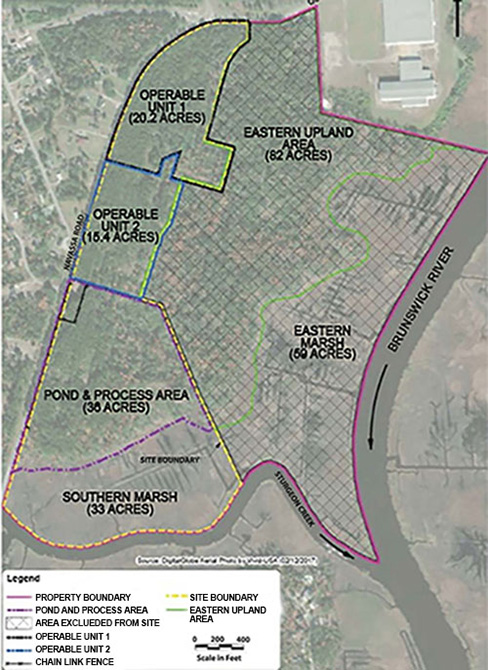
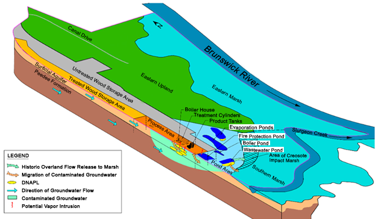
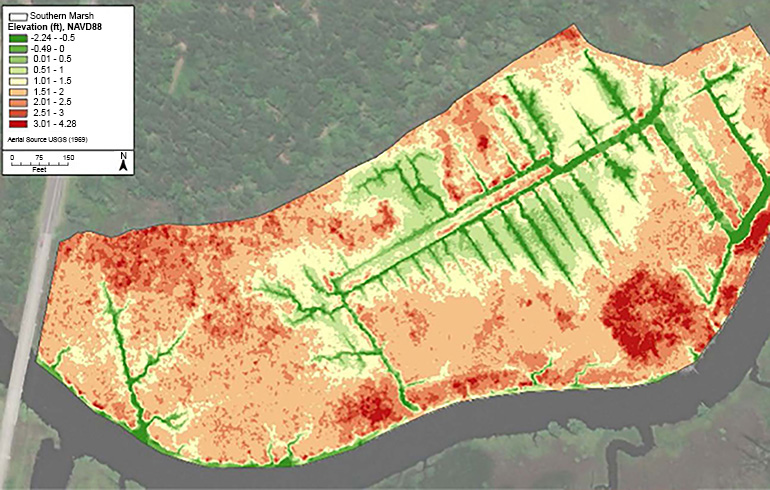
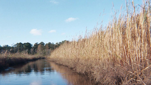
Cleanup Objectives: Remediate surface soil, subsurface soil, groundwater and marsh sediment contaminated by past use of the site for wood treating operations. Contaminants of concern include dense non-aqueous phase liquid (DNAPL), creosote constituents, fuel-related constituents, pentachlorophenol and dioxins. The site comprises about 70 acres formerly occupied by the wood treating facility and approximately 30 acres of a tidal wetland area known as the "southern marsh." The southern marsh is situated at the confluence of Sturgeon Creek and the Brunswick River.
Green Remediation Strategy: The U.S. Environmental Protection Agency (EPA) incorporated best management practices (BMPs) to reduce the environmental footprint of characterizing contamination across the site. Investigative BMPs have included:
- Use direct-sensing technologies such as thermal sensors, the rapid optical screening tool (ROST™), laser-induced fluorescence (LIF) units, and cone penetrometers (CPTs) to collect real-time data in noninvasive manners and enable dynamic field decisions.
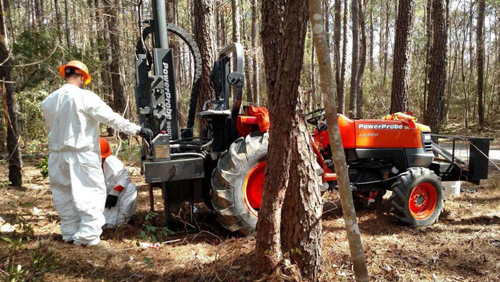
- Use direct-push technology rather than larger hollow-stem auger drill rigs for subsurface sample collection, to avoid using more disruptive equipment, minimize drill cutting generation and disposal, and increase sample collection efficiency.
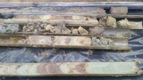
- Use vibratory drilling technology rather than conventional auger drill rigs or piston cores to advance soil or sediment cores for sampling at deep depths or installing monitoring wells, to minimize drill cuttings and reduce field time and associated resource usage.
- Use passive sampling techniques to screen or monitor contaminant concentrations in environmental media, to minimize the need for more resource-intensive grab or core sampling, generation of investigation-derived waste and disturbance of environmental media.
- Use remote sensing technologies such as unmanned aerial vehicle (UAV) imaging and terrestrial LiDAR scanning to rapidly and non-invasively identify and map field locations and depths where quantitative data should be collected.
Results:
DNAPL Investigations
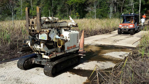
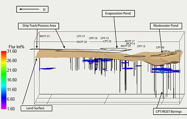
- Used a combined CPT/ROST system during an expanded site inspection and phase I remedial investigation to classify soils and identify subsurface areas where DNAPL may be present. The system used a truck-mounted tunable laser connected to a down-hole sensor. Seventy-five CPT/ROST borings were advanced in the process and pond areas, along Navassa Road, and the wood storage areas, and two were advanced in the offsite eastern upland area. The depths ranged from 2 feet below ground surface (bgs) to 50 feet bgs.
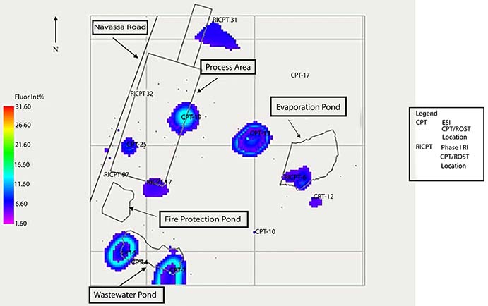
- Used the Tar-specific Green Optical Screening Tool (TarGOST®) during a supplemental remedial investigation to profile DNAPL occurrence and classify subsurface soil. TarGOST is an LIF screening tool designed to detect subsurface DNAPL by measuring fluorescence of polycyclic aromatic hydrocarbons. DNAPL profiling was conducted in 83 TarGOST borings and 28 deep soil borings in the process area, pond area and southern marsh. Follow-up screening involved profiling in 55 TarGOST borings and advancing 19 additional deep soil borings in approximately 50- to 100-foot intervals along multiple transects.
- Used direct-push GeoProbe® equipment to advance CPT/ROST and TarGOST tooling at shallow depths.
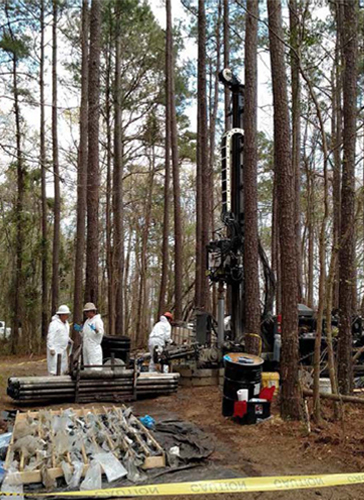
- Used sonic (rotary vibratory) drilling to advance deep soil borings along a west-east transect bordering the southern marsh. Specific drilling locations were identified by using the TarGOST data obtained through earlier GeoProbe deployment.
- Developed a three-dimensional (3D) model to refine DNAPL characterization and the CSM by combining TarGOST, CPT/ROST, and soil boring data sets. The 3D model is being used to develop a more surgical approach to delineating DNAPL, which is a source of dissolved-phase groundwater contamination, and to inform the site's feasibility study.
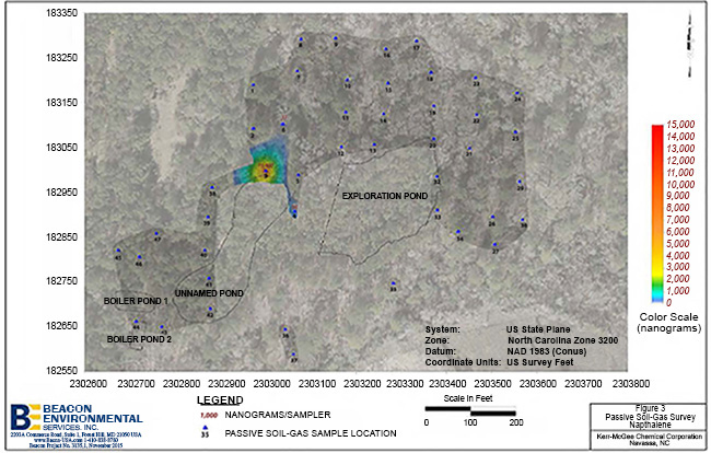
- Used passive soil gas samplers at 45 locations along with a portable gas chromatograph/mass spectrometer to assess potential source areas in the pond area, using naphthalene as a creosote indicator.
Sediment Investigations
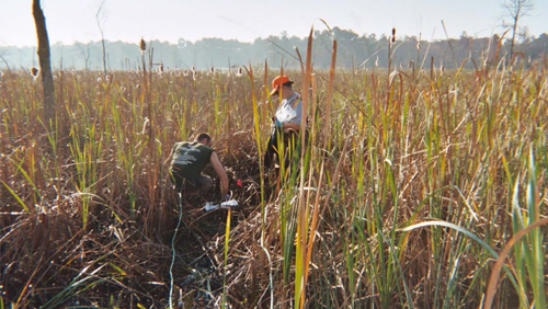
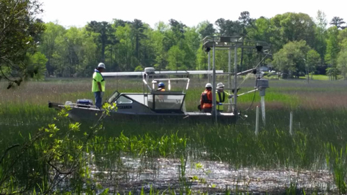
- Used high-resolution aerial thermal imagery in the southern marsh to focus sediment sampling on possible water discharges and therefore target locations for passive sampling. The thermal imagery obtained via UAV flights over several days identified 52 thermal anomalies. This remote sensing approach significantly reduced subsequent collection of sediment samples and associated disturbance in the southern marsh ecosystem.
- Used handheld thermal sensing cameras to precisely select 30 southern marsh locations for passive diffusion sampling, bulk sediment sampling and water sampling. This imaging technique revealed discharge areas, identified mixing zones, and enabled field teams to move sample locations based on real-time observations, thereby improving understanding of how the groundwater, pore water and tidally influenced surface water moves in the marsh.
- Used passive sampling techniques in accordance with EPA's 2017 methodology to quantify ecological risks and develop the basis for sediment remedial goals based on pore water. A total of 99 polyethylene passive samplers were placed, each mounted on a steel frame and extended six inches into the subsurface. Passive samplers indicate the average concentration of freely dissolved chemical in sediment porewater over the deployment period (a minimum of 30 days), rather than a snapshot of concentrations in a dynamic system influenced by tidal cycles and rain events. Passive sampling also avoids removing the marsh sediment, thereby allowing repeated sampling at the same locations throughout site investigation as well as remediation activities and long-term monitoring.
- Deployed vibracoring equipment to obtain sediment cores in the southern marsh. The sampling tubes were driven with a high-frequency, low-amplitude vibrating device into unconsolidated sediment in saturated or nearly saturated conditions.
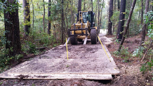
- Emplaced wood or hollow-HDPE mats to protect the ground and marsh sediments from drill rigs deployed in the southern marsh.
Groundwater Investigations
- Using sonic drilling rather than conventional auger drilling techniques to construct all temporary and permanent monitoring wells.
- Planning use of passive sampling devices to understand the profile of dissolved contaminants along the groundwater- pore water- surface water interface and the mobile fraction of contaminants in wells and piezometers used for water level measurements.
- Using the CSM refinements to focus the additional investigations and target remedial action for the site's operable unit 5, which will address groundwater DNAPL and the dissolved plume.
- Collaborating with the U.S. Army Corps of Engineers to assess potential site-specific vulnerabilities and adaptation measures associated with the impacts of climate change, such as greater tidal influence or future interactions between the site's groundwater and surface water.
Property End Use: Anticipated residential, commercial, industrial or recreational use.
Point of Contact: Erik Spalvins, U.S. Environmental Protection Agency Region 4
Update: February 2022